https://urbanyvr.com/canadas-most-expensive-condo-gets-8-million-price-cut ,
https://urbanyvr.com/transformation-of-former-post-office-into-the-post-by-quadreal-well-underway ,
https://www.skyscrapercenter.com/compare-data/submit?type%5B%5D=building&status%5B%5D=COM&status%5B%5D=UC&status%5B%5D=UCT&status%5B%5D=STO&status%5B%5D=PRO&base_city=724&base_height_range=0&base_company=All&base_min_year=1900&base_max_year=9999&skip_comparison=on&output%5B%5D=list
Friday, December 28, 2018
Thursday, December 27, 2018
The Louis-Hippolyte Lafontaine Bridge–Tunnel
https://en.wikipedia.org/wiki/Louis-Hippolyte_Lafontaine_Bridge%E2%80%93Tunnel
https://www.mtlblog.com/news/this-is-what-the-la-fontaine-tunnel-will-look-like-when-its-done
https://montrealgazette.com/news/local-news/rebuilding-louis-hippolyte-la-fontaine-tunnel-a-four-year-ordeal
https://www.transports.gouv.qc.ca/fr/projets-infrastructures/projets/reseau-routier/projets-routiers/CMM/louis-hippolyte-lafontaine/Documents/Documentation/pres-tlhl-briefing-2017-06-27.pdf
Wednesday, December 26, 2018
Four Seasons luxury hotel in Vancouver to close
https://www.theglobeandmail.com/canada/british-columbia/article-four-seasons-luxury-hotel-in-vancouver-to-close-amid-complaints-of ,
http://dailyhive.com/vancouver/four-seasons-hotel-vancouver-closing-2020 ,
http://dailyhive.com/vancouver/four-seasons-vancouver-hotel-future-use ,
https://urbanyvr.com/four-seasons-downtown-vancouver-closing
http://dailyhive.com/vancouver/four-seasons-hotel-vancouver-closing-2020 ,
http://dailyhive.com/vancouver/four-seasons-vancouver-hotel-future-use ,
https://urbanyvr.com/four-seasons-downtown-vancouver-closing
Some buldings can be renovated & expanded, but in this case, a new owner will likely just want to start from scratch.
Monday, December 24, 2018
Friday, December 14, 2018
Sunday, December 9, 2018
Friday, December 7, 2018
Wednesday, December 5, 2018
Tuesday, December 4, 2018
Saturday, December 1, 2018
Saturday, November 24, 2018

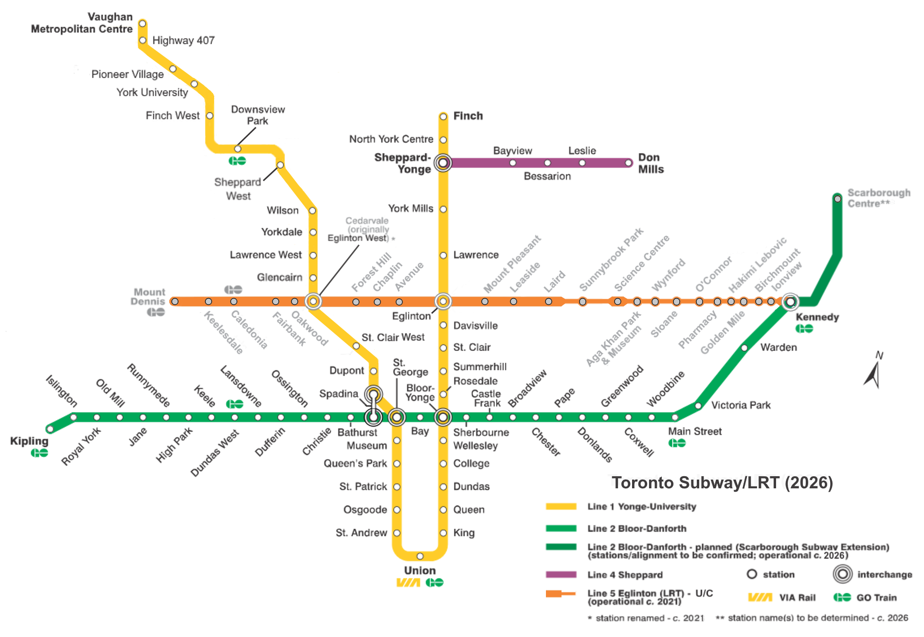
TTC Subway...
https://en.wikipedia.org/wiki/Toronto_subway
 https://upload.wikimedia.org/wikipedia/commons/d/dd/Toronto_Subway_2026.png
http://dailyhive.com/toronto/line-1-partial-closure-november-24-25 ,
http://dailyhive.com/toronto/ttc-delay-overcrowding-video ,
http://dailyhive.com/toronto/ttc-code-red-report-lack-funding ,
http://dailyhive.com/toronto/ttc-in-movies-tv-youtube-2017 ,
https://en.wikipedia.org/wiki/Bombardier_Innovia_Metro#Toronto
 https://upload.wikimedia.org/wikipedia/commons/b/b7/Toronto_2011_wiki.jpg
http://dailyhive.com/toronto/environment-canada-weather-advisory-toronto-november-15-2018
https://en.wikipedia.org/wiki/List_of_North_American_rapid_transit_systems_by_ridership
https://en.wikipedia.org/wiki/Medium-capacity_rail_system#List_of_systems
http://dailyhive.com/toronto/line-1-partial-closure-november-24-25 ,
http://dailyhive.com/toronto/ttc-delay-overcrowding-video ,
http://dailyhive.com/toronto/ttc-code-red-report-lack-funding ,
http://dailyhive.com/toronto/ttc-in-movies-tv-youtube-2017 ,
https://en.wikipedia.org/wiki/Bombardier_Innovia_Metro#Toronto
http://dailyhive.com/toronto/environment-canada-weather-advisory-toronto-november-15-2018
https://en.wikipedia.org/wiki/List_of_North_American_rapid_transit_systems_by_ridership
https://en.wikipedia.org/wiki/Medium-capacity_rail_system#List_of_systems
Montreal metro
https://en.wikipedia.org/wiki/Montreal_Metro#Building_the_Metro
https://en.wikipedia.org/wiki/MPM-10
https://en.wikipedia.org/wiki/Montreal_Metro#Laval_extension
https://en.wikipedia.org/wiki/Montreal_Metro#Ridership
https://en.wikipedia.org/wiki/List_of_North_American_rapid_transit_systems_by_ridership
| Formation | 9 articulated cars per train |
|---|
| Train length | 152.43 m (500 ft |
|---|
https://en.wikipedia.org/wiki/Montreal_Metro#Laval_extension
https://en.wikipedia.org/wiki/Montreal_Metro#Ridership
https://en.wikipedia.org/wiki/List_of_North_American_rapid_transit_systems_by_ridership
1450-west-georgia-street-vancouver-wesgroup
http://dailyhive.com/vancouver/1450-west-georgia-street-vancouver-wesgroup
http://dailyhive.com/toronto/line-1-partial-closure-november-24-25 ,
http://dailyhive.com/toronto/ttc-delay-overcrowding-video ,
http://dailyhive.com/toronto/ttc-code-red-report-lack-funding ,
http://dailyhive.com/toronto/ttc-in-movies-tv-youtube-2017 ,
http://dailyhive.com/toronto/environment-canada-weather-advisory-toronto-november-15-2018
UBC Museum of Anthropology
http://dailyhive.com/vancouver/ubc-museum-of-anthropology-moa-military-base
https://www.ubc.ca/ubc-now/2018/if-these-walls-could-talk.html
https://www.google.ca/maps/place/The+University+of+British+Columbia/@49.2695086,-123.260294,154m/data=!3m1!1e3!4m5!3m4!1s0x0:0xc79dd4e7732aa2f3!8m2!3d49.2606052!4d-123.2459938
http://www.montrealgazette.com/2008+Bill+Reid+carving+Raven+First+display+Museum+Anthropology+Bill+Reid+Rotunda/8451987/story.html
Wednesday, November 21, 2018
Tuesday, November 20, 2018
Monday, November 19, 2018
Sunday, November 18, 2018
Saturday, November 17, 2018
Friday, November 16, 2018
proposal-for-full-bay-bridge-bike-path-gains-steam-but-needs-cash
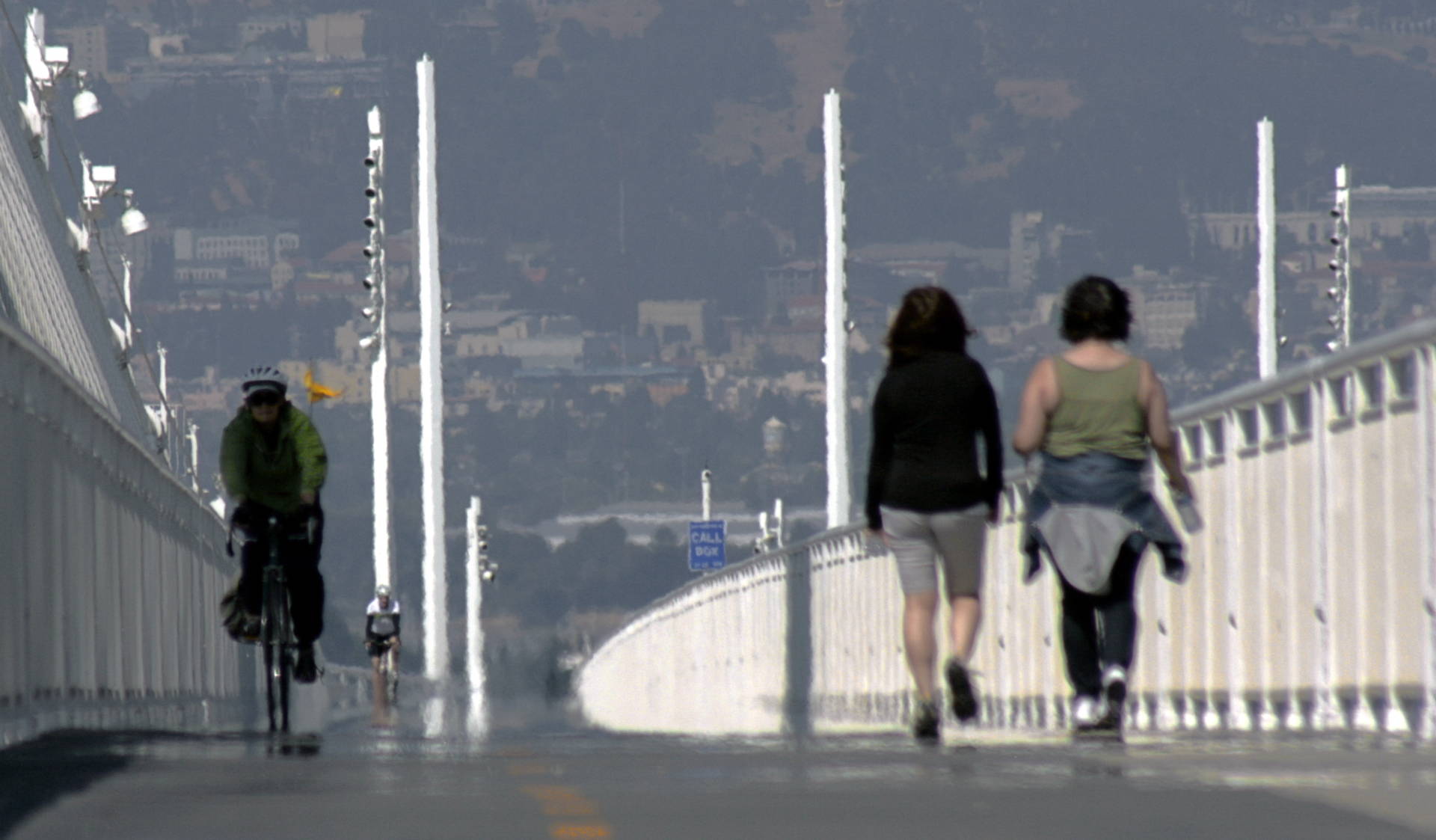
It's long been a dream for pedestrians and cyclists. But unless you've got wheels, making a trip across the Bay Bridge remains an impossibility.
When the bridge's new east span opened in 2013, the 15-foot-wide shared-use path that debuted with it was essentially a "bridge to nowhere." Later in 2016, the path was extended as far as Yerba Buena Island. But there still isn't a clear way to bike or walk into San Francisco from the East Bay.
Now, the Bay Area Toll Authority (BATA), along with Caltrans and a team of engineers, have come up with a preliminary design plan to extend the path all the way into the city, via Yerba Buena Island and across the west span of the bridge into downtown San Francisco.
On Monday, November 19, locals can check out the preferred design at a public presentation at the Bay Area Metro Center (375 Beale St.). In addition to a question-and-answer session, the presentation will include a virtual reality experience where you can "stand" on the proposed path.
https://hoodline.com/2018/11/proposal-for-full-bay-bridge-bike-path-gains-steam-but-needs-cash?pd00=7c14a275-afd5-413d-b1af-5c415e13c729&pd01=e1e48877-051d-471e-bbb9-ae621b49198d&pd02=pl-search&pd99=6e0401e8-435c-49fd-8324-8fe46c9e930e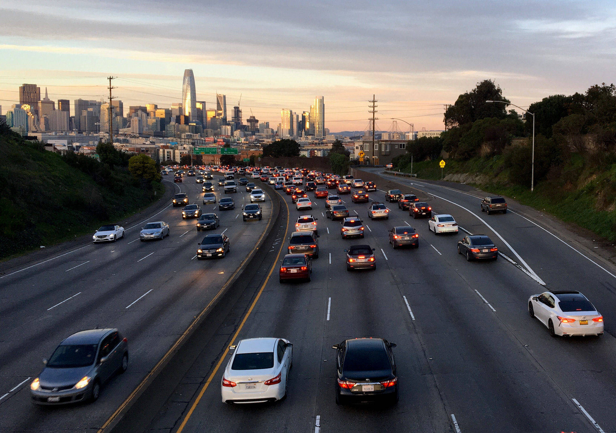
https://www.kqed.org/news/11700881/the-10-best-places-to-watch-the-worst-bay-area-traffic-congestion?pd00=a1b5b157-06a8-47e1-b04c-f63d3d577bbe&pd01=e1e48877-051d-471e-bbb9-ae621b49198d&pd02=pl-search&pd99=d48c6017-d22e-413e-bd73-ab8e53743fa5
Wednesday, November 7, 2018
Friday, November 2, 2018
Montreal train-reseau-electrique-métropolitain
http://dailyhive.com/montreal/montreal-skytrain-train-reseau-electrique-metropolitain
Montreal can always do more, simply because its not trapped under a Vancouver like mentality.
broadway-subway-granville-station-street-location-vancouver
http://dailyhive.com/vancouver/broadway-subway-granville-station-street-location-vancouver
http://dailyhive.com/vancouver/ubc-broadway-subway-funding-campus
http://dailyhive.com/vancouver/canada-line-new-trains-model-rotem-2020
http://dailyhive.com/vancouver/short-platforms-and-trains-is-the-skytrain-canada-line-under-built-and-nearing-capacity
http://dailyhive.com/vancouver/translink-mayors-council-broadway-subway-surrey-lrt-march-2018
Deltaport Third Berth Project


https://www.portvancouver.com/development-and-permits/status-of-applications/deltaport-third-berth-project/
https://www.portvancouver.com/development-and-permits/status-of-applications/deltaport-terminal-road-and-rail-improvement-project/
http://www.robertsbankterminal2.com/
email: centerm.expansion@portvancouver.com
http://dailyhive.com/vancouver/port-of-vancouver-roberts-bank-terminal-2-expansion

Sunday, October 28, 2018
Monday, October 22, 2018
Sunday, October 14, 2018
Skytrain-Canada-Line-Oakridge-41st-Avenue-Station-upgrades
http://dailyhive.com/vancouver/skytrain-canada-line-oakridge-41st-avenue-station-upgrades
It's so difficult to get things done in BC when there are so many restrictions & limitations.
http://dailyhive.com/vancouver/oakridge-centre-redevelopment-vancouver-2018-design
http://dailyhive.com/vancouver/oakridge-centre-redevelopment-architecture-august-2018
http://dailyhive.com/vancouver/oakridge-centre-688-west-41st-avenue-vancouver
http://dailyhive.com/vancouver/oakridge-centre-redevelopment-architecture-august-2018
http://dailyhive.com/vancouver/oakridge-centre-688-west-41st-avenue-vancouver
Sunday, October 7, 2018
Friday, October 5, 2018
History of the Ambassador Hotel in Los Angeles
https://en.wikipedia.org/wiki/
Its is so sad and tragic that such an American historical landmark was bulldozed.
Friday, September 28, 2018
Tuesday, September 25, 2018
Monday, September 24, 2018
urban bridges
http://www.waiward.com/project/bridges
https://www.stantec.com/en/markets/transportation/bridges
https://www.stantec.com/en/projects/canada-projects/a/anthony-henday-drive-southeast ,
https://www.google.ca/maps/place/Edmonton,+AB/@53.5069857,-113.570762,1100m/data=!3m1!1e3!4m5!3m4!1s0x53a0224580deff23:0x411fa00c4af6155d!8m2!3d53.544389!4d-113.4909267
"Over the last 40 years, population growth meant additional traffic along I-75 in Lee County—one of Florida’s main north-south thoroughfares. To address the traffic increase, the Florida Department of Transportation is widening 33 miles of I-75 from four to eight lanes. The goal? Enhance mobility for people, commerce, and industry."
https://www.stantec.com/en/projects/united-states-projects/i/i-75-caloosahatchee-river-bridge-widening
Early analysis determined that there was some reserve capacity for additional weight on the existing piers and foundations, indicating that pier cap extensions were a feasible approach for supporting a widened bridge deck. A more conventional pier widening scheme would require construction from the foundation level up.
https://www.cisc-icca.ca/projects/whitemud-drive-quesnell-bridge-widening/
Saturday, September 22, 2018
Saturday, September 8, 2018
Thursday, September 6, 2018
Monday, August 27, 2018
Thursday, August 23, 2018
Miami
https://en.wikipedia.org/wiki/List_of_tallest_buildings_in_Miami#Tallest_buildings_list
http://skyscraperpage.com/diagrams/?stateID=52&status=15
https://en.wikipedia.org/wiki/List_of_tallest_buildings_in_Florida#Tallest_buildings
 http://data.websitebox.com/data/users/0009/251/uploads/Future-miami-skyline-from-Brickell-Magazine1.jpg
http://www.get2livingmiami.com/New-Projects
http://skyscraperpage.com/diagrams/?stateID=52&status=15
https://en.wikipedia.org/wiki/List_of_tallest_buildings_in_Florida#Tallest_buildings

http://www.get2livingmiami.com/New-Projects
Wednesday, August 22, 2018

amazon-leases-major-new-seattle-office-tower-pointing-continued-growth-hometown

https://www.geekwire.com/2017/amazon-leases-major-new-seattle-office-tower-pointing-continued-growth-hometown/
https://www.geekwire.com/2018/dramatic-new-3d-images-show-ongoing-boom-alter-seattles-skyline/
https://www.geekwire.com/2018/boom-view-time-lapse-video-seattle-growth-goes-viral-look-panocams-best-shots/
Portland-architecture-firm-aims-really-high-proposal-tower-tallest-west-coast
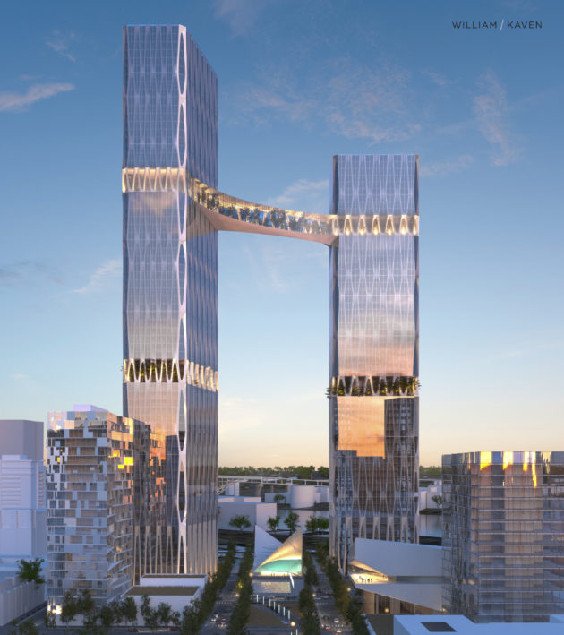
"A proposed redevelopment project in Portland would reshape that city’s skyline, with plans that include, among other things, towering skyscrapers connected by a glass-enclosed botanical bridge that would be 680 feet in the air and span a distance of 236 feet.
Of the two tallest central towers, one would exceed 970 vertical feet..."
https://www.geekwire.com/2017/portland-architecture-firm-aims-really-high-proposal-tower-tallest-west-coast
Portland hasn't been allowed to grow as tall as Seattle, SF & LA.
Thursday, August 16, 2018
port of seattle
https://www.portseattle.org/maritime/cruise
https://www.portseattle.org/places/smith-cove-cruise-terminal-pier-91
https://www.portseattle.org/places/bell-street-cruise-terminal-pier-66
https://www.portseattle.org/page/northwest-seaport-alliance
https://www.portseattle.org/page/public-transit-link-light-rail
https://www.portseattle.org/page/transportation-tofrom-sea-tac-airport
https://en.wikipedia.org/wiki/Port_of_Seattle#Current_issues
port of vancouver
https://www.portvancouver.com/cargo-terminals/
https://porttalk.ca/centermexpansion
https://porttalk.ca/centermexpansion/photos
https://www.portvancouver.com/port-dashboard/jurisdictional-map/
https://pmv-sdg.maps.arcgis.com/apps/webappviewer/index.html?id=13ca65587104430ba21f0d4860aabe88
Email: centermexpansion@portvancouver.com
https://porttalk.ca/centermexpansion
https://porttalk.ca/centermexpansion/photos
https://www.portvancouver.com/port-dashboard/jurisdictional-map/
https://pmv-sdg.maps.arcgis.com/apps/webappviewer/index.html?id=13ca65587104430ba21f0d4860aabe88
Email: centermexpansion@portvancouver.com
Wednesday, August 15, 2018
Tuesday, August 14, 2018
Monday, August 13, 2018
Monday, August 6, 2018
Saturday, August 4, 2018
Edmonton: LRT, Stantec and other skyscrapers
https://en.wikipedia.org/wiki/Capital_Line#Stations
https://globalnews.ca/news/4370864/edmonton-ironworkers-picture-stantec-skyscraper
https://skyscraperpage.com/cities/?buildingID=104164
https://globalnews.ca/news/4225798/stantec-tower-tallest-building-in-edmonton
https://skyscraperpage.com/diagrams/?countryID=1&status=15
https://globalnews.ca/news/4370864/edmonton-ironworkers-picture-stantec-skyscraper
https://skyscraperpage.com/cities/?buildingID=104164
https://globalnews.ca/news/4225798/stantec-tower-tallest-building-in-edmonton
https://skyscraperpage.com/diagrams/?countryID=1&status=15
Thursday, August 2, 2018
Monday, July 30, 2018
Sunday, July 29, 2018
Saturday, July 28, 2018
Tuesday, July 24, 2018
Tuesday, July 17, 2018
stumps vs tall buildings
http://saveourskylineyvr.ca/
https://cityhallwatch.wordpress.com/tag/tall-buildings/
https://i.pinimg.com/originals/a1/27/68/a12768d28b2bc7f117eeaedef550751e.jpg 1969
https://i.pinimg.com/originals/55/82/7e/55827ec36d93ed6456b9a428010579cf.jpg 1973
http://miss604.com/2015/10/then-and-now-from-vancouver-city-hall.html
https://i.pinimg.com/originals/c8/d3/b1/c8d3b1809bea3ec2a6a2f8a07243489c.jpg
Granville Street Bridge...
https://commons.wikimedia.org/wiki/File:Looking_north_along_the_Granville_Street_Bridge_towards_Downtown_Vancouver_1934.jpg
http://www.cbc.ca/news/canada/british-columbia/vancouver-history-vancouver-archive-1.3319002
http://www.vancouversun.com/1975+south+shore+False+Creek+gets+first+wave+development+this+aerial+view+Vancouver/4531701/story.html
https://www.pinterest.ca/pin/474426141980563253/
https://www.flickr.com/photos/45379817@N08/9660269876/in/faves-benbradley/
https://railforthevalley.wordpress.com/2010/09/02/plans-for-a-new-six-lane-pattullo-bridge-revealed-translinks-next-fiasco/
If only the Pattullo+Bridge could have been built to be as wide as the SHB or the GSB...
Tuesday, July 10, 2018
Saturday, July 7, 2018
Monday, July 2, 2018
Sunday, July 1, 2018
Friday, June 29, 2018
Thursday, June 28, 2018
Wednesday, June 27, 2018
Tuesday, June 26, 2018
the-building-of-Houston's-freeways
http://abc13.com/traffic/the-building-of-houston-freeways/3038357
https://www.chron.com/news/houston-texas/houston/article/Major-I-45-improvement-project-kicks-into-10962361.php
https://www.chron.com/news/houston-texas/houston/article/What-Houston-will-look-like-after-TxDOT-s-11138906.php
http://www.ih45northandmore.com/docs4/20170327_NHHIP_Presentation_Project%20Overview%20Briefing%20for%20Website.pdf
Sunday, June 24, 2018
Stunning photos show what's lurking below city streets, from Paris to dusty Underground tunnels in London
http://www.dailymail.co.uk/travel/travel_news/article-5856485/What-lies-beneath-Stunning-photos-whats-lurking-city-streets.html
https://en.wikipedia.org/wiki/Aldwych_tube_station
http://uk.businessinsider.com/inside-londons-abandoned-aldwych-underground-station-tube-2018-1
http://www.urban75.org/blog/take-a-photo-tour-of-the-abandoned-aldwych-tube-station-in-central-london/
http://www.urban75.org/blog/the-abandoned-aldwych-tube-station-in-london-history-and-videos/
Saturday, June 23, 2018
Vancouver mayoral candidate Wai Young really doesn't want any more Bike Lanes
https://www.straight.com/news/1093651/vancouver-mayoral-candidate-wai-young-really-really-really-doesnt-bike-lanes
https://dailyhive.com/vancouver/wai-young-vancouver-mayoral-campaign-2018
https://www.straight.com/news/1093746/memo-wai-young-bike-lanes-save-lives-and-crackpot-transportation-policies-jeopardize
http://www.vancourier.com/news/mayoral-candidate-wai-young-promises-to-scrap-bike-lanes-in-vancouver-1.23344700
Monday, June 18, 2018
Sunday, June 17, 2018
Thursday, June 14, 2018
Monday, June 11, 2018
Thursday, June 7, 2018
Wednesday, June 6, 2018
Monday, June 4, 2018
Saturday, June 2, 2018
Chicago: CTA...
seaports
https://theloadstar.co.uk/new-priok-container-terminal-will-change-face-logistics-indonesia/
https://www.porttechnology.org/news/psa_launches_2.9_billion_terminal_expansion_project
https://www.porttechnology.org/news/tianjin_port_becomes_largest_n4_terminal_complex
https://worldmaritimenews.com/archives/245142/development-of-tuas-terminal-phase-ii-moves-forward/
https://worldmaritimenews.com/archives/252623/port-of-amsterdam-words-and-actions/
https://www.porttechnology.org/news/port_of_rotterdam_wants_eu_to_invest_in_infrastructure
https://www.porttechnology.org/news/liebherr_provides_harbour_crane_for_irish_bulk_port#liebherr_maritime_cranes
https://worldmaritimenews.com/archives/252466/carnivals-brisbane-terminal-gets-conditional-approval/
http://www.shippingtandy.com/features/singapore/
Singapore
https://skyscraperpage.com/diagrams/?countryID=118&status=15
https://snappygoat.com/s/?q=+singapore
 https://snappygoat.com/b/ca454559aa51d3ad2d83319ffe991f07381be1bd
 https://snappygoat.com/b/e9a4c0e6b74c480510d16f30176e9be6693a6701
 https://snappygoat.com/b/86c42999ab20811bfe008b18391a7fdb9612690b
 https://snappygoat.com/b/fb8a39ea76b5ead7e9d969e2a4bededac503166a
 https://snappygoat.com/b/f9790353b1ce61c599e55d89ac599063b5c21021
 https://snappygoat.com/b/fb2ea286b14d2961807ab12a18d8817de34bd8ad
 https://snappygoat.com/b/9af9cc89891c5c6c68315e003a615b01bb9cf5ec
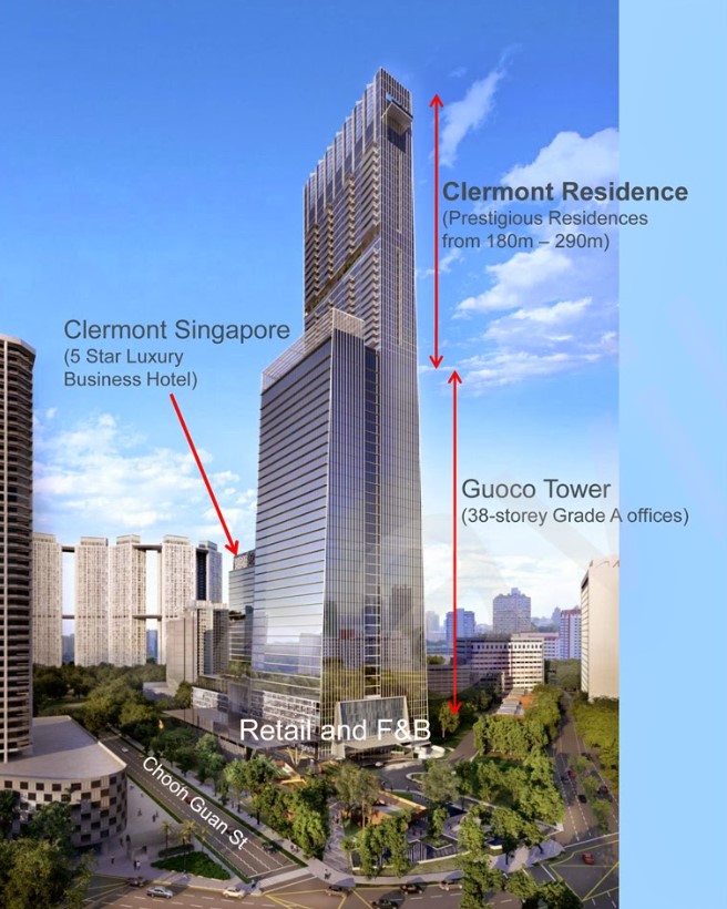
http://clermont.tanjongpagarsingapore.com
https://www.straitstimes.com/business/tanjong-pagar-centre-new-tallest-building-in-singapore-after-20-years
 https://klse.i3investor.com/files/my/blog/img/bl2363_2.jpg , https://klse.i3investor.com/blogs/omightycapital/92935.jsp
http://www.shippingtandy.com/features/singapore/
https://snappygoat.com/s/?q=+singapore
http://clermont.tanjongpagarsingapore.com
https://www.straitstimes.com/business/tanjong-pagar-centre-new-tallest-building-in-singapore-after-20-years
http://www.shippingtandy.com/features/singapore/