https://cityhallwatch.wordpress.com/2026/05/02/opinion-the-yiyby-critique-bilsker
https://www.skyscrapercenter.com/building/the-stack/35667 Only 38 floors.
https://en.wikipedia.org/wiki/Royal_Centre_(Vancouver) Just 37 stories.
https://en.wikipedia.org/wiki/Columbia_Center Seattle's tallest has 76 stories.
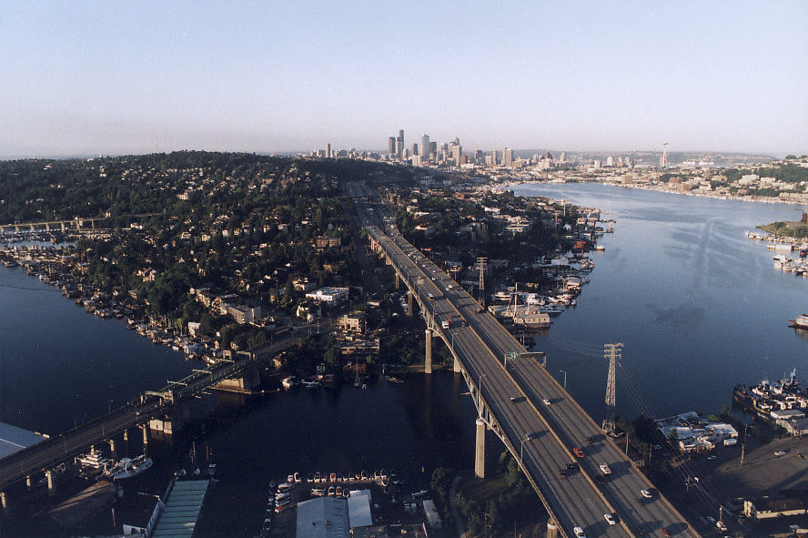
https://en.wikipedia.org/wiki/Ship_Canal_Bridge 12 lanes consisting of three 4 lane sections.
Mostly short buildings, short trains and narrow bridges are all part of the imposed symbolism to keep Vancouver small and backwards.
While Seattle had its first 50 story office tower in 1969 and Calgary in 1984, stubborn Vancouver still won't permit any office tower to have a 40th floor.
A 30-35 story office tower would be impressive if it was in Victoria, Kelowna, Kamloops and Prince George. However, what's impressive in backwards Vancouver & backwater BC isn't impressive in Alberta, Ontario, Quebec, Washington State, Victoria State, NSW, Queensland & WA...
Stumpy buildings, short trains and narrow bridges makes for the Vancouver trifecta of B$ city planning.
https://www.google.com/maps/place/Fort+McMurray,+AB 10 lanes. Only the TCH bridge between Surrey and Coquitlam in BC has been allowed to have as many lanes as this. Some people still wish that everything could have remained funneled into just 2 or 3 lanes each way.
https://www.google.com/maps/place/Quesnell+Bridge 8 lanes in Edmonton.
https://www.google.com/maps/place/Hwy.+2A+Red+Deer+City+Centre+Bridge 6 lanes.
https://www.google.com/maps/place/Calgary,+AB 10 lanes.
https://www.google.com/maps/place/Calgary,+AB 8 lanes.
https://www.google.com/maps/place/Lethbridge,+AB It has 6 lanes. Being from backwards Vancouver, its amazing that this 6 lane bridge wasn't funneled into just 2 lanes each way. That's what happened with the Knight_Street_Bridge.
https://www.google.com/maps/place/Hwy.+2A+Red+Deer+City+Centre+Bridge As a 5 lane TCH crossing, it only has 1 less lane than the 6 lane Iron Bridge in congested, backwards Vancouver. Since Alberta isn't under anything like the imposed BC restrictions, this crossing will likely be eventually upgraded to have 6 lanes, plus 2 wide emergency lanes & 2 wide shoulders that could provide 4 lanes each way, some day.
https://www.google.com/maps/place/Winnipeg,+MB A TCH bridge with 9 lanes, because no one from narrow-minded Vancouver was able to get them to narrow this crossing. The TCH Iron Bridge in Vancouver just has 6 lanes. No bus and LRT bridge has ever been built next to it, so far.
https://www.google.com/maps/place/Winnipeg,+MB A 6 lane crossing.
As of 2026, congested Vancouver only allows 2 bridges to have 6 lanes. A total of 5 lanes were removed from 3 Vancouver bridges. Had Vancouver built a series of proper bus and bike bridges, no lanes would have been removed.
Despite NW trying to be one of the smallest cities in BC, Surrey is set to become the biggest city in BC. Fortunately, small NW & backwards Vancouver can't stop that from happening. However, narrowminded NW was able to force a narrower new bridge to Surrey.
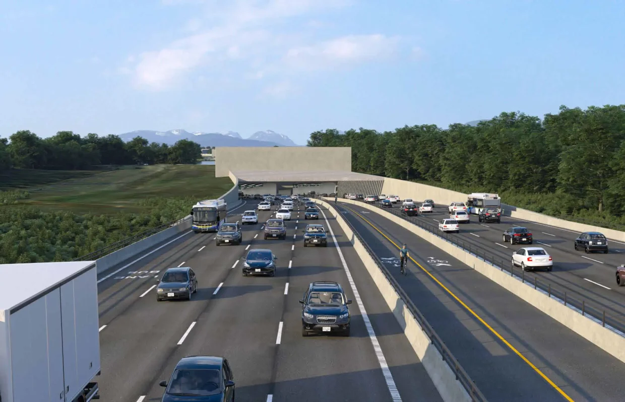
This bridge-replacement is one of the best examples of BC bottleneck-chokepoint planning today.
McBride_Blvd. and Royal_Ave_in_New_Westminster are mostly 4 lane corridors.
King_George_Boulevard and Scott_Road both are at least 4 lanes wide. One might think that the new bridge should have had 10 lanes, or at least 8 lanes, because two 4 lane boulevards, a 4 lane avenue and a 4 lane road, are all funneled into a bridge that opened with only 2 lanes each way. The old bridge that it replaced was also a 4 lane crossing. A congestive approach to transportation planning is the name of the game in backwards B.C.
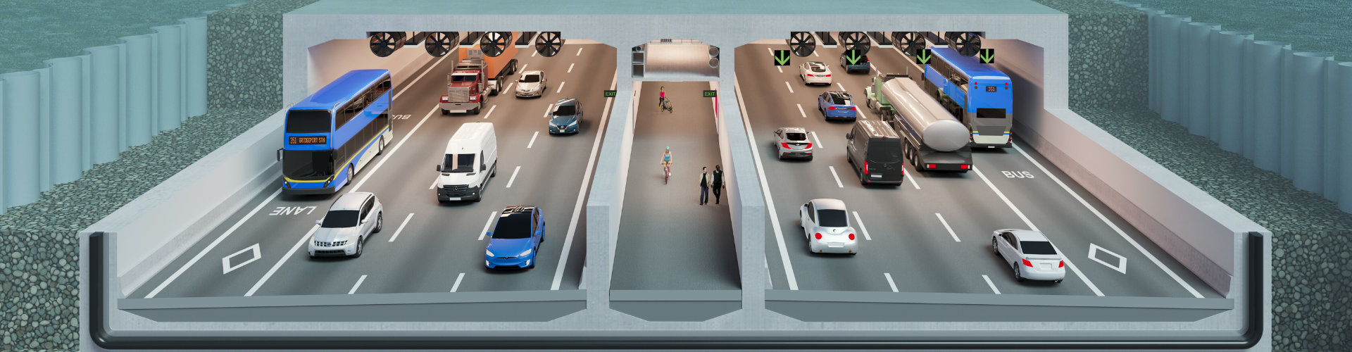
https://upload.wikimedia.org/wikipedia/commons/thumb/d/d7/Stalewasem_Bridge_%282026-03%29.jpg/960px-Stalewasem_Bridge_%282026-03%29.jpg At the very least, this new 4 lane bridge should have had enough room for 2 wide emergency lanes, 2 wide shoulders and especially, 2 bus lanes. There should have been a provision for a lower deck for LRT, bus and truck lanes, given that this is supposed to be a seaport region.
The narrowmindedness planning by Greater Vancouver to still have mostly narrow crossings, has made it very difficult to implement a proper regional express bus network, let alone BRT.
The first 2 Skytrain lines only have station lengths that can barely accommodate the new 5 car trains. The YVR Line or the C Line, has stations than can only accommodate a 2.5 car train, some day. Given that the Skytrain network is a multibillion dollar transit system, all of the stations should have been designed to gradually accommodate 8-10 car trains, but that's what a proper big city would do.
https://vancouver.citynews.ca/2026/05/02/expo-86-40-years-later-the-memories-live-on
Four decades later and Greater Vancouver remains so far behind with the scale of its infrastructure.
.jpg/960px-Stalewasem_Bridge_(2026-03).jpg)