Was a 450 foot height restriction just by chance, or was it intentionally made to be very close to 451 Fahrenheit? Despite being around the same size as Paris, Boston & SF, Vancouver remains as a very restrictive city.
Any tall building in SL City is under 450 feet. Honolulu is still stuck around the 450 foot maximum, while San Diego is stuck at 500 feet. Even Rio DeGennaro still has shorter buildings than Vancouver, BC. Washington, DC has strict height limitations like Paris. However, W,DC could eventually set up their own equivalent of La_Defense. Its a fine example of allowing tall buildings just beyond the city limits.
https://en.wikipedia.org/wiki/Fahrenheit_451 (1953) By the 1950s, so many things were already banned, watered down or scaled back in provincial backwater Vancouver. Generations later, there was the No Fun City mind virus that further tried to cancel out things in such a small city with so much red tape and other ridiculous obstacles.
https://en.wikipedia.org/wiki/Fahrenheit_451_(1966_film) By the mid and late1960s, the city made sure that its first office tower to have more than 29 floors wouldn't be until the 1970s. Its highly doubtful that Vancouver will have an office tower at, or over 40 stories by 2030. However, Burnaby and Surrey could, because they aren't under the extreme restrictions of the Vancouver Mind Virus (VMV).
It wasn't until 1973 when Vancouver allowed its first building to be taller than the Los_Angeles_City_Hall. https://en.wikipedia.org/wiki/Los_Angeles_City_Hall
The Scotia_Tower (stump) is a good reference point to visualize the small scale of backwater Vancouver, as its about the same height as the Los_Angeles_City_Hall at 453'.
https://www.skyscrapercenter.com/building/scotia-tower/4396 453'
https://skyscraperpage.com/b65/vancouver/the-scotia-tower 452'
https://en.wikipedia.org/wiki/One_Wall_Centre It opened in 2001 at 157.8 m (518 ft). Its 49 feet shorter than the Philadelphia_City_Hall.
https://en.wikipedia.org/wiki/Philadelphia_City_Hall Opened in 1901 at 548 ft (167 m).
https://en.wikipedia.org/wiki/Fahrenheit_451_(2018_film) By 2018 it was quite apparent that Vancouver was in the process of allowing for more buildings over 450 feet. However, nothing has been permitted to reach 700 feet, so far. A tower over 1000 feet would help to water down its provincial mindset.
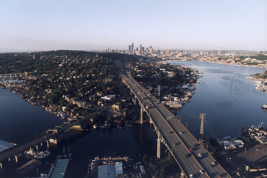
https://upload.wikimedia.org/wikipedia/commons/thumb/1/14/Vancouver_panorama_%2849988799796%29_%28cropped%29.jpg/3840px-Vancouver_panorama_%2849988799796%29_%28cropped%29.jpgSF, Sydney & Auckland are just as scenic as Vancouver & warmer throughout the year. They all have taller building than what Vancouver currently permits. Seattle is just as scenic as Vancouver, but its allowed to function like a proper big city, because it doesn't have the imposed restrictions like Vancouver has. While its cold, damp & depressing like Vancouver during the fall & winter, Seattle usually gets noticeably hotter summers than Vancouver, BC. The tallest building in Seattle is the 76 story B of A office tower.
https://upload.wikimedia.org/wikipedia/commons/thumb/5/57/LA_Skyline_Mountains2.jpg/1280px-LA_Skyline_Mountains2.jpg While the L.A. City Hall looks like a stump there, in Vancouver it would still be one of the prominent buildings.
Everything is so small or scaled back in Vancouver. Even the Greater Vancouver mountains aren't allowed to be as tall as the ones in L.A. While the San_Francisco_Bay & Port_Phillip Bay by Melbourne are big next to their cities, English_Bay in_Vancouver is so much smaller. Its even smaller than Elliott_Bay by Seattle.
Vancouver really needs to have bus and HOV bridges built next to its mostly narrow & congested bridges. Only a 5 car Skytrain is the max on the first 2 lines and ultimately, just a 2.5 car joke of a train on the YVR-Canada Line.
Selective+Door+Operation can allow a short train to have an extra car at each end, despite a shorter platform.
https://upload.wikimedia.org/wikipedia/commons/thumb/5/5e/Vancouver_sunset_%28J%29.jpg/3840px-Vancouver_sunset_%28J%29.jpg https://upload.wikimedia.org/wikipedia/commons/thumb/6/69/Los_Angeles_with_Mount_Baldy.jpg/3840px-Los_Angeles_with_Mount_Baldy.jpgAustralia like the USA, has some big & tall cities on the Pacific Rim. However, Vancouver symbolically kept watering down its size, because that's how you demonstrate a reluctance towards proper urban planning & growth.
Oddly enough, the imposed small scale Vancouver mentality & agenda wasn't adopted by most cities around the world. Officially, there is no Vancouver Mind Virus (VMV), but somehow something like it keeps manifesting, just like the BCMV.
Despite its size, Canada has less than 1% of the worlds population. Its been difficult enough just for Canada to even have half of 1% of the worlds population.
One expects Melbourne and Sydney to be proper big cities. However, Australia has big stuff at both ends of the country.
https://en.wikipedia.org/wiki/Sir_Leo_Hielscher_Bridges#Design Its a 12 lane crossing in Brisbane.
https://en.wikipedia.org/wiki/Narrows_Bridge_(Perth) 10 lanes with 2 commuter train tracks in the middle.
https://en.wikipedia.org/wiki/Brisbane_Skytower It has 90 floors. https://en.wikipedia.org/wiki/Q1_(building) Almost has 80 floors.
Perth Central_Park_(skyscraper) at 51 floors and 108_St_Georges_Terrace at 50. Very restrictive Vancouver still won't permit any office tower to have a 40th floor. Calgary and Seattle each have a few over 50 stories.
So far, provincial Halifax hasn't been allowed to be on a similar scale as Boston and Montreal.
https://en.wikipedia.org/wiki/Angus_L._Macdonald_Bridge 3 lanes.
https://en.wikipedia.org/wiki/A._Murray_MacKay_Bridge 4 lanes.
The scale of Vancouver is kept below that of Calgary & Seattle or even Auckland, in some ways.
https://en.wikipedia.org/wiki/Lions_Gate_Bridge A classic 3 lane BC bottleneck-chokepoint. No parallel bus and truck tunnels and especially, no LRT tunnel.
Provincial backwater Victoria isn't allowed to be on a similar scale of Wellington, NZ.
https://en.wikipedia.org/wiki/Johnson_Street_Bridge Another BC 3 lane wonder.
_(cropped).jpg/3840px-Vancouver_panorama_(49988799796)_(cropped).jpg)

.jpg/3840px-Vancouver_sunset_(J).jpg)
